Project site in Brazil:
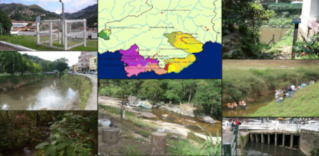
At first, the emphasis will be on improving the characterization of the hydro-meteorological regime related to the dynamics of floods in the mountainous region of the state of Rio de Janeiro, focusing on the Piabanha river watershed covering an area of about 2000,00 km 2 that contributes to the Paraiba do Sul river basin, which integrates partially the states of São Paulo, Rio de Janeiro and Minas Gerais in the southeast of Brazil, having along its drainage area of approximately 55,000 km 2 different types of human occupation, leading to challenges that should be addressed with respect to land use and soil cover jointly with different sewage and industrial effluent treatments. In addition, it should be noted that the southeast basins in Brazil present a hydro-meteorological and hydrological connection with Amazonia (6,000,000 km 2 ) taking into account climate change projections and scenarios and the behavior of floodings and droughts including the operation of the hydroelectric power generation system in Brazil. In this sense, the understanding of the mechanisms and pattern behaviors of wetlands, for example, could be addressed as part of the overall water and energy balance for Amazonia and for the southeast of Brazil (Fig. 1).
Therefore, as additional objectives, we will be exploring the integration of the entities active in the area of water resources in the Amazon basin region and in the mountainous area of Rio de Janeiro, the development of tools for acquisition and analysis of data and information by remote sensing – exploiting its potential for monitoring water and climate change – in order to use them for solving general and specific problems related to each region of the Amazon River basin and watershed in the mountainous area of Rio de Janeiro. The information thus obtained should build a system to support the decisions facing the management of water resources and preserve the environment. Methodologies will be developed and evaluated at the scale of the basin, such as computer modeling techniques, based on the implementation of particular areas monitored by remote sensing.